

Paris

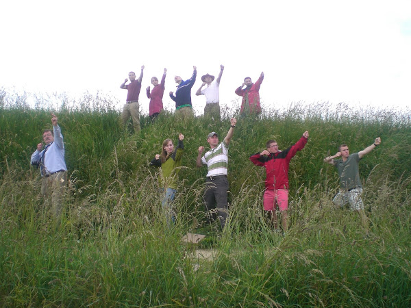
Hotel des Invalides. From the left: Tweeter, Jersey, KAARRLL!, Ty, le #*@%, Doc Rogers, the Duchess, the Sir, Lenny, and Fez
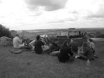
Archers at Crecy
Map 1: French Advance on Crecy
Map 2: English Defense at Crecy
Saturday, June 21, 2008
Tuesday, June 17, 2008
Day Seven: Agincourt and Crecy
On the afternoon of 26 August 1346, Philip Valois found Edward III’s army arrayed on the field east of the village of Crécy-en-Ponthieu, and the result was one of the most critical battles of the Hundred Years’ War. Nearly 662 years later, a group of ten from the United States Military Academy walked the same ground and attempted to make sense of the conflicting reports offered by contemporary and modern historians, alike.
After a brief stop at the observation tower situated on the reputed spot of the windmill from which Edward oversaw his victory, we began our tour in the village of Crécy, at the EMHISARC (EM ulation HIS toire and ARC haeology) museum that commemorates not only this epic battle, but also boasts a collection of articles from the World Wars, including a V1 display. We were met by the organization’s president, and also by Sir Philip Preston, notable historian and local expert. They greeted us warmly and treated us to lunch at the museum before showing us the displays. The museum, though dedicated largely to the Battle of Crécy, includes several activities that allow younger history enthusiasts to experience medieval warfare by practicing their martial skills with practice longbows and swords. Those with more scholarly interests can examine the indoor terrain model of the battlefield. The three-dimensional depiction that takes up several square meters of the room demonstrated the difficulty historians face in identifying the precise array of the English army, in particular. Maps drawn by various historians lie juxtaposed with text from the chroniclers’ accounts, but no definitive arrangement can be agreed upon. With this in mind, we moved to the battlefield itself to try to pair our understanding of the battle with the actual terrain upon which it was fought. Sir Philip led us first to the site of the French approach.
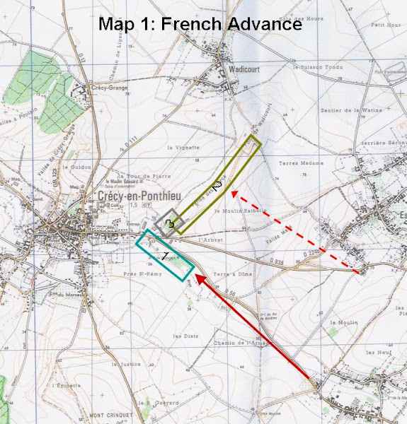
Whether the French army approached the English along one route or several, we do know that they had spent the previous night downriver in Abbeville. The lead cavalry units were the first to reach the battlefield, followed by some Genoese crossbowmen. The king was probably still a good distance from the English when their formation was sighted. The dismounted infantry were surely far behind their compatriots on horseback. Historians generally accept the French line of advance to have been roughly along modern route D 56, indicated by the red arrow on Map One.
Map 1: The French Advance
The French would have advanced from Abbeville generally along modern route D-56 (solid red arrow). As you pointed out, the 16-mile march would have left them wanting for water, which they would seek to replenish in the streams marked by Box 1. Some historians have depicted the French advancing along multiple lines (e.g. red dashed arrow). However, the point is irrelevant to a discussion of the actual attack against the English position, because the terrain, particularly the steep bank in Box 2, would have funneled them back to the west to attack around the left side of the wood, Box 3. The photo that I attached to this email is taken mid-bank, at which point the bank is only 4-5 meters in height. Even there, it was completely impassable for any cavalry formation.
Map 2: The English Defense
This is the more contentious, and therefore more interesting, of the two sketches. Chroniclers' reported that the English formation was arrayed along the hill between Crecy and Wadicourt. Most historians have taken this to mean that the line extended precisely from town to town. Our interpretation still has the defensive line on the hill between the two towns, but we determined that such a thin line would not suit the tactical needs of Edward on this particular terrain. The solid blue bars denote dismounted men-at-arms. The dotted lines represent archers. The solid blue square approximates the location of the windmill from which Edward III directed the battle. We suggested that the archers would have been well-served tying into the terraces (1). They could have prepared to refuse any attempt against their right flank by having an additional line of archers, perhaps of 50m, angled along the edge of the terrace. My sketch has the Black Prince’s 1200 men-at-arms occupying a line approximately 150m in length. This would have allowed for a depth of 8 ranks, which would be appropriate considering for what a great proportion of the fighting his battle was responsible. The next two lines of archers (2) would have been able to take advantage of the sloped terrain (see photo). I have them occupying a total of 700m. If 400 archers were detached to protect the baggage trains (2000 would later be used as a reserve at Verneuil in 1424), the remaining 5600 archers (including Northampton’s 3000) could be evenly distributed into 8 ranks along the entire line. Likely, the stock of arrows would not have been evenly distributed, but supplied in greatest proportion to the most active parts of the line. Similarly, the prince’s 3000 Welsh spearmen could form four ranks along the whole front of the archers (at the bottom of the slope with the archers occupying the vantage position?), perhaps with 200 concentrated at the weakest point in the line (3). The English far left (4) would reflect their efforts to refuse the right flank, and would fire directly into the great bank, which would be well within their bowshot. Any French who attempted to advance through this valley to outflank the English right (as they would have to do if they did not want to circumnavigate all of Wadicourt), would suffer quickly for their underestimation of the power of the English longbow. The king’s reserve of 1600 men-at-arms and 4000 archers, I have placed relatively arbitrarily (5), but it would certainly make sense that they would have three key roles: 1) to prevent the French from outflanking the English far right by circumnavigating Crecy, 2) to protect the king (who was in or near the windmill), and 3) to be prepared to fill gaps in the line. I believe the position accounts for all three of these responsibilities, and, even if it does not have direct support from the chronicles, it certainly does not conflict with any of them so far as I am aware. The baggage train, as PROF Rogers pointed out, was tied to the wood to the north of town. We believed that this reverse-slope position makes sense.
Crécy was an exciting stop for us. Not only did we benefit from having Sir Philip as our personal guide through the museum and battlefield site, but, more than any other stop, we were able to challenge conventional views of how this historic battle was fought.
Our next stop, after a short drive through the countryside, would be the most famous of all Hundred Years’ War battles: Agincourt.
~MAJ Christian Teutsch
Today, 16 June 2008, we visited the site of the battle of Agincourt. This historic battle took place on 25 OCT 1415. While visiting this battle site our primary concern was to determine the original and final positions of the English longbowmen. Placement of the longbowmen in battle was one of the primary concerns for the English army during The Hundred Years War.
The maps at the site of the battle of Agincourt indicate that the original position of the English Longbowmen was at the end of the battle field pressed against the town of Maisoncelles. Judging from the current terrain of the battle field it is hard to believe that the English commander, King Henry V, would have placed the Longbowmen in this particular spot. The longbowmen would have been in the middle of a ditch. The slopes on either side of the ditch would have given the English archers very poor visibility. The English longbowmen would have been sitting unable to defend themselves as the French Cavalry charged them.
Our resident medieval history expert Dr. Rogers had estimated the placement of the English longbowmen on the same side of the field approximately 500 meters north of the spot the maps at the battle site had placed the archers. Dr. Rogers had originally believed this was the spot because he felt the longbowmen would have had the greatest ability to fire, and visibility from this position. Upon viewing the position from the battlefield, he decided against his original placement of the archers. This position was obstructed by an inter-visibility line directly in front of the archers. The entire length of the position would have been too low in the field for the longbowmen to fire accurately.
After an exhausting search of the battlefield were able to decide on a single spot that seemed reasonable for the placement of the English longbowmen. This position was located 500 meters to the north of the position Dr. Rogers had originally estimated for the site of the English longbowmen, or 1000 meters north of the position the maps at the battle site had estimated. We choose this spot because it was wide enough to place the entire line of English longbowmen on it, and it was the tip of a crest in the field. This position would have allowed the longbowmen to see the enemy approaching, and then fire repeating accurate volleys of arrows. In addition the incline to the top of the crest would have made a French cavalry charge increasingly difficult.
During our visit to the Agincourt battle site we also visited the resting ground for the majority of dead Frenchmen. The Chronicles written on the monument pictured above tell the gruesome realities of October 25th 1415. According to the monument the bodies of the deceased French had been stacked higher then a man, and the majority of them had been killed after being trampled or suffocating in the mud. The monument featured a full sized crucifix surrounded in a circle of trees. This would have placed the pile of deceased French 150 meters in front of the line of English longbowmen.
The visit to this historic battlefield was particularly beneficial because of the extensive revisions we were able to make on our original estimation of the placement of the English longbowmen. Had we continued to rely on maps, whether standard or via Google Earth, we would have never been able to realize that placement of the longbowmen at either of the two sites originally estimated would have been highly unlikely. We also would not have been able to discover what we now believe was the position of the longbowmen 150 meters behind the crucifix monument.
Visiting these historic battle sites allowed everyone on the trip to gain a greater appreciation for the dynamic nature of history. After our first day visiting the battle sites we began to realize that terrain can often be the deciding factor in a battle. Our own understanding of the importance of terrain and ground position in a battle was solidified by our search for the position of the English archers as well as the various other positions we searched for during our staff ride.
After a brief stop at the observation tower situated on the reputed spot of the windmill from which Edward oversaw his victory, we began our tour in the village of Crécy, at the EMHISARC (EM ulation HIS toire and ARC haeology) museum that commemorates not only this epic battle, but also boasts a collection of articles from the World Wars, including a V1 display. We were met by the organization’s president, and also by Sir Philip Preston, notable historian and local expert. They greeted us warmly and treated us to lunch at the museum before showing us the displays. The museum, though dedicated largely to the Battle of Crécy, includes several activities that allow younger history enthusiasts to experience medieval warfare by practicing their martial skills with practice longbows and swords. Those with more scholarly interests can examine the indoor terrain model of the battlefield. The three-dimensional depiction that takes up several square meters of the room demonstrated the difficulty historians face in identifying the precise array of the English army, in particular. Maps drawn by various historians lie juxtaposed with text from the chroniclers’ accounts, but no definitive arrangement can be agreed upon. With this in mind, we moved to the battlefield itself to try to pair our understanding of the battle with the actual terrain upon which it was fought. Sir Philip led us first to the site of the French approach.
Whether the French army approached the English along one route or several, we do know that they had spent the previous night downriver in Abbeville. The lead cavalry units were the first to reach the battlefield, followed by some Genoese crossbowmen. The king was probably still a good distance from the English when their formation was sighted. The dismounted infantry were surely far behind their compatriots on horseback. Historians generally accept the French line of advance to have been roughly along modern route D 56, indicated by the red arrow on Map One.
Map 1: The French Advance
The French would have advanced from Abbeville generally along modern route D-56 (solid red arrow). As you pointed out, the 16-mile march would have left them wanting for water, which they would seek to replenish in the streams marked by Box 1. Some historians have depicted the French advancing along multiple lines (e.g. red dashed arrow). However, the point is irrelevant to a discussion of the actual attack against the English position, because the terrain, particularly the steep bank in Box 2, would have funneled them back to the west to attack around the left side of the wood, Box 3. The photo that I attached to this email is taken mid-bank, at which point the bank is only 4-5 meters in height. Even there, it was completely impassable for any cavalry formation.
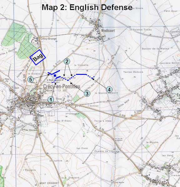
Map 2: The English Defense
This is the more contentious, and therefore more interesting, of the two sketches. Chroniclers' reported that the English formation was arrayed along the hill between Crecy and Wadicourt. Most historians have taken this to mean that the line extended precisely from town to town. Our interpretation still has the defensive line on the hill between the two towns, but we determined that such a thin line would not suit the tactical needs of Edward on this particular terrain. The solid blue bars denote dismounted men-at-arms. The dotted lines represent archers. The solid blue square approximates the location of the windmill from which Edward III directed the battle. We suggested that the archers would have been well-served tying into the terraces (1). They could have prepared to refuse any attempt against their right flank by having an additional line of archers, perhaps of 50m, angled along the edge of the terrace. My sketch has the Black Prince’s 1200 men-at-arms occupying a line approximately 150m in length. This would have allowed for a depth of 8 ranks, which would be appropriate considering for what a great proportion of the fighting his battle was responsible. The next two lines of archers (2) would have been able to take advantage of the sloped terrain (see photo). I have them occupying a total of 700m. If 400 archers were detached to protect the baggage trains (2000 would later be used as a reserve at Verneuil in 1424), the remaining 5600 archers (including Northampton’s 3000) could be evenly distributed into 8 ranks along the entire line. Likely, the stock of arrows would not have been evenly distributed, but supplied in greatest proportion to the most active parts of the line. Similarly, the prince’s 3000 Welsh spearmen could form four ranks along the whole front of the archers (at the bottom of the slope with the archers occupying the vantage position?), perhaps with 200 concentrated at the weakest point in the line (3). The English far left (4) would reflect their efforts to refuse the right flank, and would fire directly into the great bank, which would be well within their bowshot. Any French who attempted to advance through this valley to outflank the English right (as they would have to do if they did not want to circumnavigate all of Wadicourt), would suffer quickly for their underestimation of the power of the English longbow. The king’s reserve of 1600 men-at-arms and 4000 archers, I have placed relatively arbitrarily (5), but it would certainly make sense that they would have three key roles: 1) to prevent the French from outflanking the English far right by circumnavigating Crecy, 2) to protect the king (who was in or near the windmill), and 3) to be prepared to fill gaps in the line. I believe the position accounts for all three of these responsibilities, and, even if it does not have direct support from the chronicles, it certainly does not conflict with any of them so far as I am aware. The baggage train, as PROF Rogers pointed out, was tied to the wood to the north of town. We believed that this reverse-slope position makes sense.
Crécy was an exciting stop for us. Not only did we benefit from having Sir Philip as our personal guide through the museum and battlefield site, but, more than any other stop, we were able to challenge conventional views of how this historic battle was fought.
Our next stop, after a short drive through the countryside, would be the most famous of all Hundred Years’ War battles: Agincourt.
~MAJ Christian Teutsch
Today, 16 June 2008, we visited the site of the battle of Agincourt. This historic battle took place on 25 OCT 1415. While visiting this battle site our primary concern was to determine the original and final positions of the English longbowmen. Placement of the longbowmen in battle was one of the primary concerns for the English army during The Hundred Years War.
The maps at the site of the battle of Agincourt indicate that the original position of the English Longbowmen was at the end of the battle field pressed against the town of Maisoncelles. Judging from the current terrain of the battle field it is hard to believe that the English commander, King Henry V, would have placed the Longbowmen in this particular spot. The longbowmen would have been in the middle of a ditch. The slopes on either side of the ditch would have given the English archers very poor visibility. The English longbowmen would have been sitting unable to defend themselves as the French Cavalry charged them.
Our resident medieval history expert Dr. Rogers had estimated the placement of the English longbowmen on the same side of the field approximately 500 meters north of the spot the maps at the battle site had placed the archers. Dr. Rogers had originally believed this was the spot because he felt the longbowmen would have had the greatest ability to fire, and visibility from this position. Upon viewing the position from the battlefield, he decided against his original placement of the archers. This position was obstructed by an inter-visibility line directly in front of the archers. The entire length of the position would have been too low in the field for the longbowmen to fire accurately.
After an exhausting search of the battlefield were able to decide on a single spot that seemed reasonable for the placement of the English longbowmen. This position was located 500 meters to the north of the position Dr. Rogers had originally estimated for the site of the English longbowmen, or 1000 meters north of the position the maps at the battle site had estimated. We choose this spot because it was wide enough to place the entire line of English longbowmen on it, and it was the tip of a crest in the field. This position would have allowed the longbowmen to see the enemy approaching, and then fire repeating accurate volleys of arrows. In addition the incline to the top of the crest would have made a French cavalry charge increasingly difficult.
During our visit to the Agincourt battle site we also visited the resting ground for the majority of dead Frenchmen. The Chronicles written on the monument pictured above tell the gruesome realities of October 25th 1415. According to the monument the bodies of the deceased French had been stacked higher then a man, and the majority of them had been killed after being trampled or suffocating in the mud. The monument featured a full sized crucifix surrounded in a circle of trees. This would have placed the pile of deceased French 150 meters in front of the line of English longbowmen.
The visit to this historic battlefield was particularly beneficial because of the extensive revisions we were able to make on our original estimation of the placement of the English longbowmen. Had we continued to rely on maps, whether standard or via Google Earth, we would have never been able to realize that placement of the longbowmen at either of the two sites originally estimated would have been highly unlikely. We also would not have been able to discover what we now believe was the position of the longbowmen 150 meters behind the crucifix monument.
Visiting these historic battle sites allowed everyone on the trip to gain a greater appreciation for the dynamic nature of history. After our first day visiting the battle sites we began to realize that terrain can often be the deciding factor in a battle. Our own understanding of the importance of terrain and ground position in a battle was solidified by our search for the position of the English archers as well as the various other positions we searched for during our staff ride.
Sunday, June 15, 2008
Day Six: Chateau Galliard and Vernieul
The day started with the usually session of PT and then we headed out about 830 to find the battlefield. Our breakfast this morning was by far the cheapest and yet the best in my opinion. We stopped near a large cathedral and grabbed breakfast from a nearby bakery. Breakfast consisted of chocolate baguettes, chocolatines (chocolate croissants), tarts of all sorts, small confectionary cakes, and other baked goods.
The battle of Verneuil took place on 14 August 1424, 9 years after the battle of Agincourt. The French army prior to the battle had avoided fighting the English, moved to the castle of Verneuil and had a Scottish allied contingent disguised as English soldiers to deceive the castle garrison into thinking that the French had defeated a large English army and that their was no relief coming for them. The English garrison ultimately surrendered and the French took the castle. Soon afterwards the relief army did appear on the outskirts of Verneuil.
The battle consisted of roughly 8000 English soldiers and about 16000 French Soldiers. The fighting was actually quite straight forward; the French cavalry and the Lombard mercenaries rode around the English flanks and attacked the rear but were driven off by the English reserve archers. The two main lines advanced on each other. The Duke of Bedford (The English regent of Henry the VI) pushed the French line back to the city moat and many of the French drowned. He turned his line around and advanced on the Scottish rear (The 6000 Scots were fighting with the French because the English was a common enemy) After the English reserve had driven off all of the cavalry; they turned and flanked the Scottish line as well. The Scots were soon surrounded and having taken an oath to never surrender or retreat, the Scots died to a man.
We began the field exercise by mirroring the advance of the French cavalry through the town of Verneuil to the battlefield. Since the terrain was relatively flat and the battlefield was only 1000 yards by 1 mile, we decided to conduct a map exercise to show the positions of both armies. We discussed how the armies would have been arrayed and why and looked for terrain features that may have affected the tactical decisions of the commanders. We then moved down the road to inspect the English position and looked at their line of advance.
One of the more interesting ideas discussed was one by Professor Rogers. The English had roughly 13000 horses with their army. The area for the baggage train was too small to fit all of these horses into. So his proposal was that since the English advanced out of the protection of the tree line and exposed their flanks, why did the French not take advantage of this and what did they do with the horses? Professor Rogers suggests that the Duke of Bedford could have ordered the valets (the men responsible for the horses, generally thought of as squires) to tie their horses together, about 3 or 4 each, and lead them out of the baggage train encampment and march to the end of the English position. Those under the Duke of Bedford advance to the right flank, those under the Earl of Salisbury to the left, and then turn and begin to form a wall of horses, four deep, along the English flanks. As the English advanced forward the line of horses would just follow. The valets would be told to just follow the horses in front of you and a massive chain could be formed that way. With an archer on the inside horse and a valet on the outside horse, a defensive wall of horses is a possible obstacle.
The purpose of a staff ride is to visit the actual battlefields and determine how the written accounts match the actual terrain. Initially, when Professor Rogers pitched his horse wall idea, I thought that he was slightly off kilter. Looking at the contour map of Verneuil, it looked as though the terrain may be too hilly or that the terrain would not allow for the construction of a horse wall. But after visiting the site and seeing the terrain, we walked through the scenario and it seems very plausible that the English could have constructed a “Horse-wall” to protect their flanks.
The day ended with us entering the city of Rouen. We had our group’s “Nice Dinner” and then we walked about the city. Turkey also won their advancement into the finals of the Euro cup as illustrated by the numerous cars driving erratically down the empty streets, honking horns and waving Turkish flags for several hours of the night.
After touring the battlefield at Verneuil, we traveled north to the city of Ville des Andelys. Here lie the ruins of the Chateau Gaillard, built by the English during the reign of Richard the Lionheart between 1197 and 1198. The castle is situated on a cliff overlooking the east bank of the Seine river. Little remains of the outer walls, but 900 years ago, the massive fortress dominated the river valley as the greatest English stronghold in the region.
Although the castle was not really involved in the Hundred Years War, it played a key role during the struggle between the French and the English in their earlier wars. In 1203, for example, John had assumed the English throne after Richard’s death, and he led the English in a campaign to conquer France. The French, led by King Philip the Second, sought to dislodge the English from their capital in Rouen. However, in order to do this, they first had to conquer the English fortifications at Chateau Guillard and gain control of the Seine river. As the French army approached the castle from the west bank, the English burned the bridge across the river, leaving the French with no way to cross. But to the dismay of the English, the French were able to create a pontoon bridge and move part of their force across the river. Recognizing the importance of the castle, King John organized a two pronged attack on the French camp. One group of English soldiers would attack the camp at dusk, while another contingent of soldiers would simultaneously travel by boat to resupply the castle and attack the French pontoon bridge. Unfortunately for the English, the boats arrived too late in the battle, and the French were able to easily ward off the English attack. After the battle, King John decided that it was too costly to invest more forces in the defense of Chateau Gaillard, so he left the castle’s garrison to fend for itself.
The French then moved into position to besiege the castle. After a few months, King Philip decided that he had waited long enough to capture the castle, and he ordered the French to begin a full assault on the castle. Using ladders to scale the castle walls, they quickly captured the outer ward of the castle, and the English fell back into Chateau Gaillard’s inner ward. The French then took to mining into the castle’s foundation in order to collapse one of the castle’s walls. While this was occurring, a French soldier noticed a tower window close to the ground. He and some of his fellow soldiers scaled the tower and climbed into the abandoned tower. Realizing that the English had locked up this part of the castle, they started trying to bash the door down. The English realized that the French were inside the castle, and they immediately started the wooden chapel on fire in order to deter the French movement into the castle. However, at this point, the French miners broke through the wall, and the soldiers quickly surged into the castle, killing or capturing the remaining English defenders.
When we visited the site of Chateau Gaillard during the staff ride, I was amazed at how impenetrable the fortress seemed. As part of the defenses, the English had dug ditches up to 30 feet deep around the castle. The walls of the towers were between two and three meters thick, and the multiple layers of defenses would have slowed any attacker, giving the defenders time to regroup and continue fighting. We also discovered that there used to be a well at the castle that was 200 meters deep, which would have supplied the English with as much water as they could gather until the well’s ropes wore out. Visiting the castle helped me to better realize its importance and the significant challenges posed by attacking or defending such a fortification as the Chateau Gaillard.
Saturday, June 14, 2008
Day Five: Poitiers
Today we visited the Poitiers battlefield. It was quite an experience to have actually traced the movements of both the Anglo-Gascon and French forces. We began the day at the Nouaille Abbey, which had already been standing for two centuries by the time of the Black Prince’s 1356 campaign. Our first movement focused on tracing one of two possible routes taken by Salisbury in his movement to close the gap in the English lines during the French advance. Our movement took us through the dense Woods of Nouaille onto “the bad road” (Maupertis). We noted that because of the presence of the Nouaille Abbey it is probable that the road we had taken to reach the Poitiers battlefield was present and could have been used by Salisbury - as it made sense for any grain that was grown on the western side of the Nouaille woods to travel through the forest rather that completely around Woods of Nouaille and to the Abbey.
We eventually reached the other side of the Woods of Nouaille and followed the Croix de la Garde road. To check our position we stopped at a farm and entered a field in order to locate a pit that was illustrated on our maps. Although the pit was not found we later noticed its position upon movement south along a road running perpendicular to Croix de la Garde. We observed the hedgerows along the way and noted their height and density. Although not very tall at this particular location, they would have been a formidable obstacle to any advancing French units.
We then proceeded south towards the supposed hilltop where the Black Prince is said to have positioned himself. Moving from the north a hill was not very noticeable but clearly defined when approaching from the south. It was noted that the hilltop was the Black Prince’s anchoring point. We then moved further south and reached the “bowl,” a densely wooded ridgeline that descended into a wetland. We concluded that the English had placed their archers along this ridge and utilized the steepness of the bowl as a way of checking any possible French cavalry charges. The Black prince extended his line from the hilltop to the “bowl.”
Upon completion of touring the “bowl” we proceeded south to the Miosson River, the very river Captal de Buch’s forded in order to attack King Jean’s forces from their rear, a very decisive moment during the battle of Poitiers – one that no doubt sealed English victory. The river was shallow and looked like it could be quickly crossed on horseback, an important note Dr. Roger’s brought up. Quick movement was a necessity, especially with defeat a distinct possibility.
We moved north along the bowl and further examined the steepness of the terrain. The site offered exceptional protection for English archers. Our southern movement along the bad road took us past more hedgerows, in particular the zig-zag hedgerow the English used to halt the French advance. It was here a gap formed in the English lines, one that was filled by Salisbury. Further south was a monument commemorating the battle of Poitiers. It was here that we tried to decide the best possible way to employ forces along severely broken ground – boulders and strangely uneven ground was common throughout the area. Warwick arrayed his men from the bowl to the monument area. It would have been ideal for the Anglo – Gascon forces to break up the advancing French lines, so utilizing the terrain in a manner that would induce this to occur was taken into account. It was decided that a straight line stretching just south of this “bad” terrain would have formed an ideal defense. Warwick’s lines would have extended to the “bowl” where English archers were firing upon French cavalry and Men at Arms.
We walked south and crossed the bridge along the bad road. We moved north to have lunch in the quant town of Poitiers. Although our original plans did not work out, we found a nice pub that served excellent food called the Auberge de Labaie. The food was fantastic and the made for a relaxing lunch where we conversed about what had been learned and sites to come.
Friday, June 13, 2008
Day Four: Auberoche
Today we began by finishing up Bergerac and traveling to Auberoche to explore that battle site.
In the Battle of Auberoche, the French were laying siege on an English fortification. Meanwhile, an English relief force was camped nearby, waiting for reinforcements in order to attack the French encampment of about 7,000 men. Fearing discovery by the French and low on supplies, the English decided to attack without waiting for reinforcements. Meanwhile, the French were sitting and joking in their camp, complacent after many months of laying siege, and were entirely unprepared for the English attack. First we wanted to determine the exact route of the English from their camp to the French camp, which required the Enlgish to cross the river. Due to their small numbers, only 1,200 men, they were relying on the element of surprise and therefore could not use the bridge due to its proximity to the French town of Le Change. We first traveled to a spot in the river which we determined would be the best fording site. After braving the thick forest of stinging nettles, we made it to the bank of the river. At this point, everyone, except the girls who were prepared to call for help if necessary, stripped down to their swimsuits and began to cross the ferocious (not really) river which came at highest to one’s waist. Thus, this river could easily be forded by the English army, especially if they were on horseback, and since the river would have been lower when they crossed in October 1344.
We then traveled to the site where the English archers were positioned. From the top of the wooded hill, we determined that the archers could move forward without being seen by the French. This wooded hill extended down to the road that served as the west border of the French camp. Upon reaching the road, we decided that, due to the steep slope from the French camp to the road, it would be very difficult for the French cavalry to attack the English archers. Even if the French had created some sort of fence as an additional protective measure, this would have served only to help the English by providing a barrier that would further keep the French from advancing to the road. Professor Rogers also pointed out that presently the hill was very thick with trees and shrubs, but during siege the woods would have been less dense because the French would have used the wood for firewood and setting up their camp.
After walking along this road, we discovered the only route of ingress for the English cavalry to the southern border of the French camp. The hill on the western border was very steep, and there was only one road that went from the road to field. At this point, we also determined that the field where the French camp was would not be quite big enough for 7,000 men and several thousand horses. We decided that it would be possible for the French to have a camp on the eastern side of the river as well, with a bridge connecting the two camps. Meanwhile, with the field only being about 150 yards wide, the 400 English cavalry could line up with 150 men across and 2-3 men deep, allowing them to cover the entire field as they began their attack against the French.
After being brutally attacked by mosquitoes, we headed up to the chapel overlooking the field, the only building remaining from the former Auberoche castle. This castle was created due to its strategic location that allowed it to easily control the river and the main road. There was only one road that led to this castle at the very top of the hill, making the castle very easy to defend. The English at this castle, once they saw the battle commence, opened fire with their archers on the French retreating to the north and pursued them on horseback, as well.
Originally, when we first examined this battle in the classroom through the aid of maps, we were left with many questions. However, having traveled and observed the terrain ourselves, has resolved many of the issues we raised in class.
Thursday, June 12, 2008
Day Three: Bergerac, Castelnaud, and Blagnac
Day 3 blog
Today we started the day off with breakfast at our hotel and then we were off to what we believed to be one of the possible sites for the Battle Bergerac. The battle could have taken place in three possible locations on the map. The site that we went to first was in a large open field that is now a pasture and an orchard. A small ditch/creek and woods mark the boundaries on each side of the field and the pasture has a huge decline from the road to the tree-line. The battle is said to have been a cavalry charge with archers shooting from the tree-line on both sides forming a “kill box”. The English waited for the French at the South side of the field and upon the French arrival from the North they allowed them to form up and charged while English archers hammered the French as they rode. In order to have a complete understanding of the terrain and the area that is available for a cavalry charge, we walked the field. We walked along the edges of the field along the wooded area and got a better look at the ditch alongside. It is possible that the English could have dug it themselves, but it wasn’t that wide and a horse could have easily just jumped over it. We also wanted to note the significance of the drop off in the cattle pasture on the other side of the rode, so we all climbed through the fence and went to the bottom of the pasture at the bottom of the decline. Looking back up at the road, you cannot see the road, the field, or any of the trees in the orchard so we concluded that the archers could have used the cliff as a possible firing point along with the tree-line in the opposite direction.
Initially when we were all over the fence the cattle in the pasture did not seem to be bothered by our presence and they simply just stayed where they were, ignoring us. Then as time wore on and we continued to analyze their home they apparently became increasingly angry about it because they started to form up into one big group. We were talking and then we turned to see a large group of cattle starring angrily at us. They just stood there….waiting….and starring….waiting….and starring and we didn’t really move any faster because we were almost done. Then, as we started to move back up from the bottom to the road, the cattle group moved again, and they too went up to the top. Dr. Rogers, Josh, Marie, and Marc were already to the fence when I heard Marie yell “Allie RUN!!!!” (note: she apparently didn’t care about the well-fare of the guys who were close behind…haha) I turned to my left and the cattle were running at us full speed, “CHARGE!” The rest of us started sprinting for the fence and we made it just as the cattle thundered past us. Once we got to the other side of the fence we all had a good laugh about it, but I have a feeling it would have been a bad day for us if we hadn’t have made it.
After we left the field we set off towards Chateau de Castelnaud. While we were driving we saw a few Chateaus that were breathtaking, and we even agreed to visit one of them on the way back from Chateau de Castelnaud. The Chateau was located at the edge of a cliff overlooking a river, a beautiful bridge, and the French countryside. It also had a fabulous view of the surrounding castles (chateaus) which we later learned played a huge role in their history. The two chateaus that were located on opposite cliffs were Chateau de Castelnaud and Chateau de Beynac. Castelnaud was owned by an English lord starting in 1405 and Beynac was owned by a French lord and they feuded for years until 1442 when the French crown besieged Castelnaud and took it back from the English. The Chateau itself it privately owned, but it has been restored and now functions as a medieval military museum. The weapons collection and other pieces in the museum are unmatched by any medieval collection in the world. Also met us at the museum. He is a French historian and has just completed his Ph.D. on The Hundred Years War.
After we finished our tours of the two Chateaus, we were off again to another possible site for the Battle of Bergerac. When went to Champ de Roque as the second site for the battle. This was the site that we had decided was the most likely place for the battle last week when we were just looking at the maps. The map gives a fairly accurate depiction of what the terrain actually looks like on the ground however, the problem with this area is that there is not an access way for the French pursuit or the English to enter into the field. The first site was fit the description and the road that flows through it would have been the perfect access point for the two armies to enter into the field. The second site also did not have a place that would have been perfect for the archers. We know they would have had to hind in the wood-line, but had they been lined up there along both sides as the literature suggests, they would not have been able shoot to the center of the field even with maximum range. While we were there we also re-examined the map for the third site, la Croix, and once we looked at it again we decided that it couldn’t have possibly been where the battle had taken place. The opening at the top was too narrow for the cavalry to enter into the field and the only place that had sufficient room for the French cavalry to form up was so large that the English would have never have chosen to defend it. The longbowmen would have never been able to reach the French forces from their position in the trees.
Wednesday, June 11, 2008
Day Two: Aiguillon and Castillon
After a long evening of sleeping off our jetlag, we began our first full day in France by getting breakfast at a local patisseire, or bakery. Baguettes in hand, we ascended once more into the fortified city (not a castle, a fact Professor Rogers emphasized repeatedly) of Carcassone. Touring the battlements, we gained an appreciation for the tremendous task taking a town would be, as ten-meter walls look much larger from their base than from the pages of an history book. We also visited a medieval "museum", whose hilariously poor introductary film featuring a jester/mime did not enlighten our understanding of the period as much as we had hoped. It did, however, have three impressive dioramas which detailed the various developmental stages of the city, from Roman frontier town to sought-after medieval stronghold.
Leaving Carcassone, we began our trip to Aiguillon, the site of a very important siege which the French were forced to abandon in response to the landing of an English invasion force. While we had studied the siege's circumstances in the classroom using Google Earth and contour maps, our visit to the site yielded several interesting insights. The fortification at Aiguillon was placed strategically at the confluence of two rivers, and the riverbanks down to the rivers were much steeper, thereby making them a more formidable defense, than we had anticipated. We also saw some rises which we thought might have been possible foundations for the walls of the bastide.
After changing our plans to accomodate slightly longer than expected tours, we set off through the French countryside to Castillon. This final battle of the war featured an attack by an English force led by the famous John Talbot against a heavily entrenched French force which made heavy use of artillery pieces. We were able to trace the French fortifications, as the trench which protected their camp was still easily visible as it was over a meter deep. Walking the field and having our legs torn to shreds by nettles allowed us to understand the difficulty of an assault against the position. We also examined a river and found that the bubbling brook which we had anticipated was not nearly as idyllic as we had assumed, as the stream was bordered by a steep hill.
After a long day of muddied clothing and nearly catastrophic knee injuries, it was excellent to sit down to another delcious French meal with the knowledge that it would be wise to protect one's legs on future battlefield tours with pants so that we leave the battlefield with more memories than scratches.
Subscribe to:
Posts (Atom)